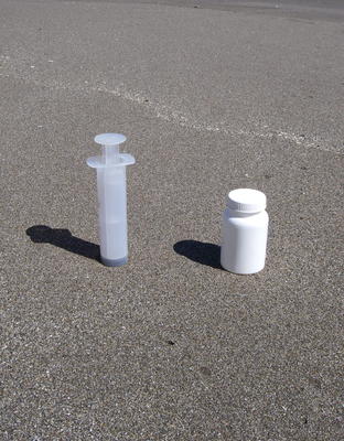
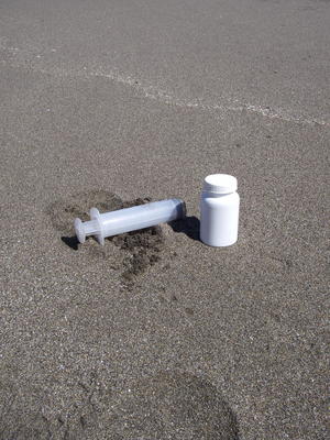
Se logra mejor muestreo cuantitativo de playas arenosas expuestas utilizando un corer de pistón. Corers pistón puede hacerse fácilmente cortando el extremo de una jeringa de plástico. La distribución de meiofauna es generalmente muy heterogénea, por lo tanto, un gran número de muestras pequeñas es preferible a un pequeño número de grandes muestras. Por supuesto, esto tiene que ser equilibrada contra la logística de tiempo disponible para muestreo, transporte y procesamiento. Típicamente tomo muestras de 50 ml con 5 réplicas, aunque esto se puede modificará en función de los requisitos de la hipótesis que se están probando. El método para la recogida de las muestras usando un corer de pistón se ilustra a continuación.
 |
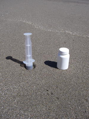 |
| Paso 1: El corer de pistón se coloca verticalmente sobre la superficie del sedimento con el pistón tocando la superficie del sedimento. | Paso 2: El tubo del corer es empujado entonces hacía el sedimento con la cabeza del pistón quedando en contacto con la superficie del sedimento. Esto es para evitar la compresión del sedimento que puede ser importante si usted está evaluando la distribución vertical de la meiofauna. Además, si el pistón no estaban en contacto con la superficie del sedimento el aire entre el pistón y la superficie del sedimento tendría que ser comprimido para impulsar el extractor en el sedimento. |
 |
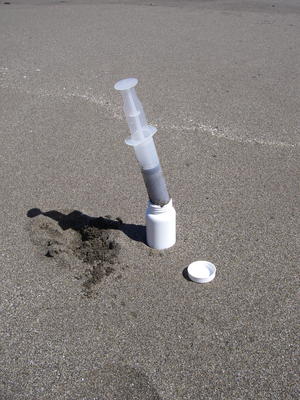 |
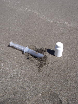
| Paso 3: Una vez que el corer ha sido insertado a la profundidad requerida se recupera la muestra. Con arenas más finas, se puede retirar el corer verticalmente y la arena se mantendrá dentro del tubo. Sin embargo, con arenas gruesas o menos compactadas la muestra puede caer fuera del tubo si levanta verticalmente. Para evitar este problema, gire el corer desde el sedimento (ilustrado). | Paso 4: La muestra debe ser transferido inmediatamente a un frasco de muestra. Si se utiliza este método en el submareal (a través de SCUBA por ejemplo) se puede insertar un tapón de goma en el extremo del corer para retener la muestra hasta que pueda ser transferido a un frasco de muestra en la orilla. |
 |
|
| Paso 5: La muestra puede ser fijada en el sitio con formalina (etc) y etiquetados. El corer debe lavar entre las muestras y se lava a fondo entre los sitios. Las jeringas de plástico son a la vez barata y fácil de perder, así que asegúrese de que usted entra en el terreno con más de uno. Con el tiempo la cabeza de la goma del pistón se degrada y no se desliza suavemente por el tubo, en este punto usted debe hacer una nueva corer. |